What’s New in Civil 3D 2026: 3D Model Viewer, Infrastructure Design Review, and Drainage Analysis Preview
Autodesk Civil 3D is a powerful design software that enables civil engineers to tackle complex infrastructure projects within a comprehensive 3D model-based environment. It streamlines the design and construction of roads and highways, land development, rail systems, and bridge projects.
With advanced tools for surface modeling, corridor design, terrain analysis, and more, Civil 3D helps reduce overall design time and improve project accuracy, empowering teams to deliver smarter, more efficient infrastructure solutions.
The 2026 release of Autodesk Civil 3D brings some exciting updates that are sure to make life easier for civil engineers, designers, and project managers. Whether you’re planning a road, a subdivision, or an entire infrastructure system, these new features are designed to improve how you visualize, collaborate, and analyze your civil projects.
In this post, we’ll walk you through the three biggest updates in Civil 3D 2026:
- The new 3D Model Viewer
- Infrastructure Design Review in Autodesk Construction Cloud
- A Tech Preview of Autodesk Drainage Analysis for Civil 3D
Let’s dive into what each of these can do and how they can improve your workflow.
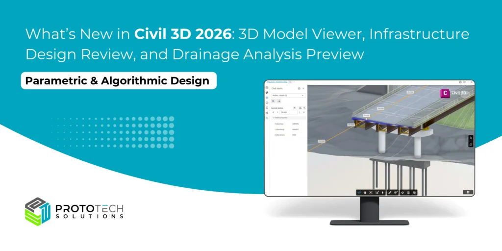
1. 3D Model Viewer: See More, Understand Faster
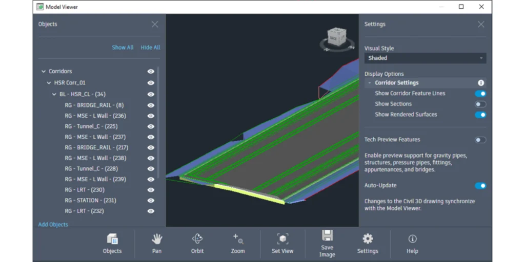
One of the most exciting additions in Civil 3D 2026 is the 3D Model Viewer. If you’ve ever struggled to picture how your corridor, surface, or pipe network fits together in three dimensions, this tool is a game-changer.
- Real-Time Visualization: The Model Viewer lets you see your design in a fully interactive 3D window, right alongside your main workspace. You can orbit, pan, and zoom around your model without interrupting your workflow.
- Object Control: The viewer includes an Objects Panel, where you can turn the visibility of specific elements on or off. Want to see just the corridor and not the surface? No problem. Need to focus on the pipe network? Just a click away.
- Instant Feedback: As you make changes in your design, the 3D view updates instantly, so you always know how edits affect the bigger picture
2. Infrastructure Design Review in Autodesk Construction Cloud: Seamless Collaboration
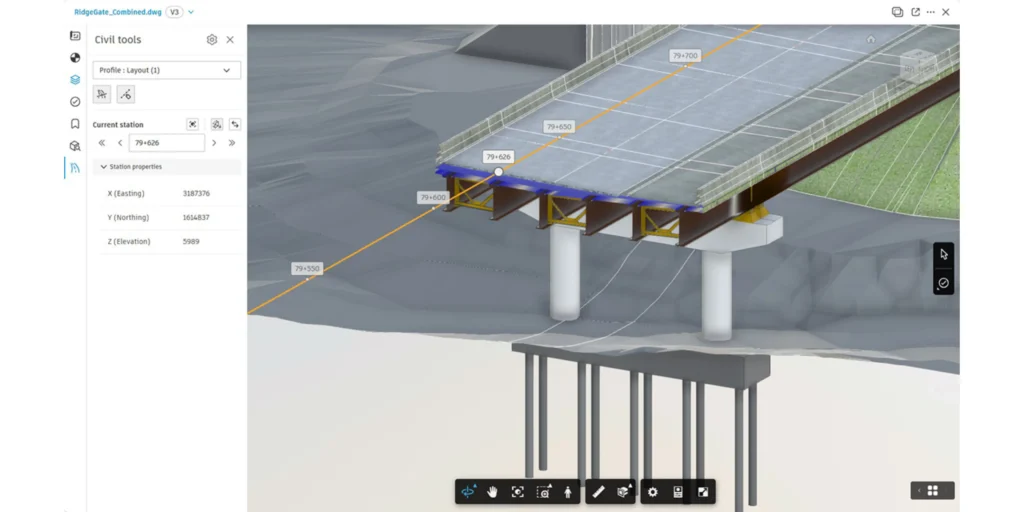
Civil 3D 2026 is now connected to the Autodesk Construction Cloud (ACC) through a feature called Infrastructure Design Review. This means you can upload your Civil 3D models directly to the cloud, where your team, clients, and other stakeholders can review and comment, all in one place. To streamline design review and project management, especially for complex infrastructure like roads, rail, and large sites.
- Project Explorer Enhancements: The Project Explorer tool now supports more advanced workflows, including rail projects. You can review, validate, and report on intricate design elements-like curves defined by speed, curvature, and cant-directly from the Civil 3D window
- Command Line Actions: New options let you run Object Set Actions from the command line, making it easier to automate reporting and updates without leaving your main workspace
- Connected Design Reviews: Integration with Autodesk Construction Cloud (ACC) enables real-time model sharing, issue tracking, and feedback review, regardless of your team’s location. This helps BIM/CAD Managers, Project Managers, QA/QC personnel, and civil/design engineers keep everyone aligned on infrastructure projects within ACC.
3. Tech Preview: Autodesk Drainage Analysis for Civil 3D
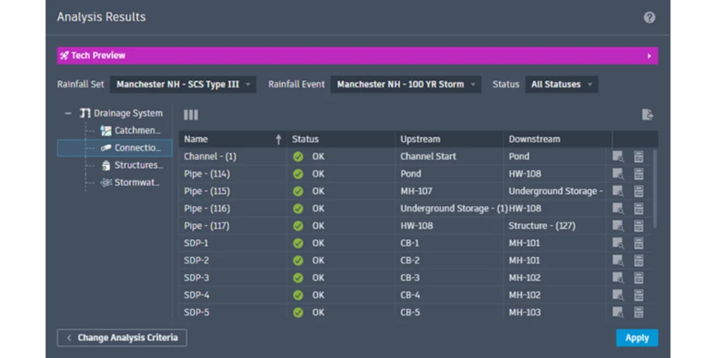
Drainage Analysis for Civil 3D 2026 introduces a Technical Preview of a powerful new toolset aimed at integrating Civil 3D’s drainage design capabilities with InfoDrainage cloud-based analysis services. This extension significantly enhances the drainage design workflow by enabling seamless connectivity between design and advanced hydraulic analysis.
Key improvements include:
- New Drainage Objects: Civil 3D 2026 introduces new objects for ponds, underground storage, and open channels, making it easier to model real-world drainage scenarios.
- Enhanced catchment delineation now supports a broader range of runoff calculation methods.
- Cloud-Based Analysis: By connecting with Autodesk’s cloud-based InfoDrainage platform, you can run simulations and get results faster-without heavy installs or complicated setups.
- Real-Time Validation: As you tweak your drainage design, you can instantly see how changes affect flows, storage, and compliance. This helps you make smarter decisions and avoid costly errors down the line
This feature is currently a tech preview, which means Autodesk is actively seeking feedback from users to make it even better. If you work with stormwater or drainage, now’s the time to try it and help shape its future.
Final Thoughts
Civil 3D 2026 is more than just a performance update, it’s a meaningful step toward smarter, more connected design workflows. It’s about making your daily work easier, more accurate, and more collaborative. The 3D Model Viewer helps you see and solve problems before they become expensive mistakes. The enhanced review tools keep your team in sync and your designs on track. And the Drainage Analysis Preview brings powerful, integrated analytics to one of the toughest parts of civil engineering.
Whether you’re a long-time Civil 3D user or just exploring what it can do, these updates are worth checking out. And if you’re part of a team, now’s a good time to start looking into how Autodesk Construction Cloud can bring your collaboration to the next level.
Think of ProtoTech Solutions for Your Civil 3D Projects
With the innovation in Civil 3D 2026 tools like the 3D Model Viewer and Autodesk Construction Cloud integration, the possibilities for collaboration and smarter design are expanding fast. Whether you’re planning a new development, updating infrastructure, or conducting detailed surveys, looking for the best partner who can maximize these tools to deliver quality results, ProtoTech Solutions is your trusted partner for precision, efficiency, and innovation in every Civil 3D project.
At ProtoTech Solutions, we specialize in delivering high-quality Civil CAD drafting services tailored to your road design, highway design, and land development project’s needs. Our expertise spans a comprehensive range of solutions, including:
- Land Development Design & Drafting
- Surveying and Site Plan Layout
- Site Grading and Drainage
- Structural Detailing and Visualization
- As-Built Surveys
- ALTA/NSPS Land Title Surveys
- Topographic Surveys
Contact us today to learn more about how we can support your Civil 3D and infrastructure projects.